KS3 Geography › Tectonic hazards

KS3 Geography › Tectonic hazards
These are the points the worksheet questions are built around.
Each year the Atlantic Ocean gains a few centimetres in width, roughly the pace at which fingernails lengthen, so North America and Europe keep edging apart. A scientist argued over a century ago that continents travel, but it took decades for the idea to be accepted.
In 1912 Alfred Wegener, a German scientist, noticed that the bulge of eastern South America seems to tuck neatly into the curve of western Africa, as if the two were pieces from one puzzle. His theory of continental drift said the continents had once been joined before slowly moving apart. He named this giant landmass Pangaea. Since a matching outline could be coincidence, he needed more proof.
Rocks and fossils supplied it. Bands of matching rock types continue from one continent onto another. Mountains in the Scottish Highlands share similar rock types and ages with the Appalachians of North America, though an ocean now separates them. Fossils point the same way. Lystrosaurus, a pig-sized creature that lived on land and could never have crossed an ocean, has turned up in India, Antarctica and Africa. Glossopteris, an ancient plant, is even more widespread, appearing in Australia, South America, Antarctica, India and Africa. The simplest way to explain these patterns is that the lands were once connected.
Even so, most scientists turned the idea down. Wegener had no explanation for what could possibly shift an entire continent, and he never discovered one. He died on an expedition in Greenland in 1930 with the idea still rejected. Everything changed in the 1950s. Surveys of the Atlantic sea floor revealed an enormous ridge of underwater mountains running along the centre of the ocean, split by a deep central valley, as though the ocean floor were being torn open. By the close of the 1960s, continental drift had been revived within a broader theory called plate tectonics.
The planet's outer layer is not one solid skin. The lithosphere is made up of the crust and the stiff topmost part of the mantle. This layer is split into huge pieces, the tectonic plates, which are always slowly shifting. Plates carry sea floor as well as land. Beneath the oceans is oceanic plate, which is thin, its crust usually only five to ten kilometres deep, but dense. Beneath the land is continental plate, which is far thicker, often thirty to fifty kilometres of crust, yet less dense.
Density means the amount of mass squeezed into a certain space. Put wood and a metal key in water and the difference is clear: the wood is less dense than the water and stays on the surface, while the denser key goes to the bottom. Plates follow a similar rule, which helps explain how they move.
It is easy to confuse a continent with a plate. A continent, such as Africa or South America, is simply one of the planet's big areas of land. A plate is a section of the lithosphere. The South American plate holds the whole of South America but also reaches east beneath the Atlantic as far as the ridge in mid-ocean, so a single plate can include both continental and oceanic parts.
Part of the missing force comes from where the two kinds of plate meet. Being denser, oceanic plate dives beneath continental plate and descends into the mantle. Scientists call this subduction, and the area where it occurs a subduction zone. The descending edge, known as the slab, is so heavy that it hauls the remainder of the plate after it. This is slab pull. A weighty chain sliding off a table shows the idea: once enough dangles over the edge, it drags the rest after it. One real example is the Nazca plate, which dives beneath the South American plate along South America's western coast.
The South American plate is also driven from the mid-Atlantic mountains. That range is an ocean ridge, a raised strip of sea floor where plates are separating. As they part, some mantle rock below turns molten, forming magma that pushes up through fractures, bursts out as lava and hardens into fresh rock. Being hot at first, this rock is part of why the ridge stands higher than the sea bed around it. Further from the ridge it cools, becomes denser and slips down the slope under gravity, pushing the rest of the plate as it goes. This is ridge push, a big part of what drives the South American plate westwards and further from Africa.
Convection currents in the mantle were once blamed for moving plates, but most scientists no longer treat them as the main cause. Today slab pull is thought to be the main force, while ridge push helps.
All of this matters because most of the world's earthquakes, and many of its volcanoes, are found along plate boundaries. Two places where plates meet are Iceland, where the Mid-Atlantic Ridge emerges above sea level, and the Andes, above the sinking Nazca plate.
In short: matching coastlines, rocks and fossils backed up Wegener's continental drift, but it was rejected for decades because he could not explain what moved the continents. The explanation turned out to be moving tectonic plates. Oceanic plate is thin and dense, while continental plate is thick and less dense. Sinking oceanic plate hauls the rest of its plate behind it through slab pull, and cooling new rock sliding off ocean ridges gives ridge push.
These are the words that appear as key term cards in the video — worth knowing cold before the test.
Revising for a test? Key terms, objectives and quiz questions on one printable page.
The 3 questions from the video, one at a time. See if you caught them.
1. About how fast is the Atlantic Ocean getting wider?
Why: The Atlantic widens by a few centimetres a year, about as fast as your fingernails grow.
2. Are South America and the South American plate the same thing?
Why: The plate carries the continent plus a big part of the Atlantic sea floor.
3. Which force do most scientists think moves the plates the most?
Why: The sinking edge of a plate drags the rest of the plate along behind it.
Score: 0 out of 3 —
Want more practice? Try the 60-second Quiz Challenge →
One page with a full answer key. Enough to check the lesson landed, and to see how the questions are written before you buy anything.
Get the free worksheet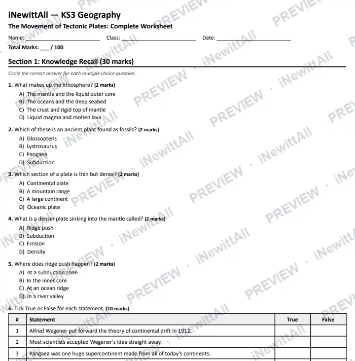
The top of page 1. The answer key is included when you buy.
£5 £6
The full worksheet and the extension pack together, with both answer keys.
Instant download with full answer keys. Print as many copies as your class needs.
£3
£3
£5 £6
Tick it off to track your progress. It's saved on this device. See my revision →
Students watch the video and do the quiz. They get a result card to paste back to you, showing their first try and best score.
This lesson's quiz questions on one sheet, with the answer key on page 2.
The quiz in big text for your classroom screen, one question at a time. Or build a 5-question Do Now starter from lessons your class has already done.
You're welcome to embed the video and link these resources in Google Classroom, Stile, Canvas, Compass or any other school platform. No need to ask.
Everything here is written to the KS3 curriculum for students aged 11–14. Print freely for the classes you teach.
More in this unit: Tectonic hazards
No spam, unsubscribe anytime. You must be 13 or over to sign up.